
|
Home Equipment Services | Field Surveys | | CR | | RPIP, TDIP | | ERT | | CSAMT | | AMT, MT | | TEM | | NanoTEM | | Streaming IP | | Seismic | | Laboratory | Applications | Consulting | Lab Properties | Ore Minerals Software About Us Contact News |
|
3322 E Fort Lowell Rd |

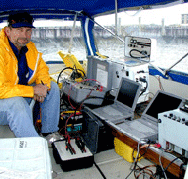
Field Surveys
Streaming IP
Streaming Resistivity / IP Applications
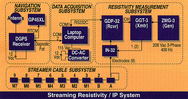
Each equipment box in the diagram above is linked to the corresponding specification file.
Applications:
- River / Lake Bottom Surveys
- Petroleum Exploration
Data Acquisition Subsystem
Navigation information transmitted from the Satloc receiver and resistivity/IP data transmitted by the GDP-32 receiver were captured using a custom program developed by Zonge Engineering. The program operates under MS-DOS from any PC-compatible platform having two COM ports. We used a Toshiba Satellite 2135CS laptop computer (25 MHz 486). Under control of this program, NMEA messages from the Satloc DGPS receiver and the resistivity and IP data strings from the GDP-32 are merged and stored into a single ASCII data file.
Differential GPS (DGPS) Navigation Subsystem
Navigation information was provided by a Model SL-3000 Satellite-based differential GPS system manufactured by Satloc (Phoenix, AZ). The main advantage of this system is that it provides real-time sub-meter navigational accuracy. No post-processing was required and it was not necessary to establish a base station monitor onshore. The Satloc receiver was set up to transmit NMEA 4-position messages upon receiving a command through its RS232C serial port. In addition, the Satloc also transmits RTCM differential correction information over a second serial RS232C port. We connected the RTCM port of the Satloc receiver directly to a Garmin 45XL handheld GPS receiver to provide a heads up display for navigation of the survey vessel while the survey was underway.
Streamer Cable Subsystem
The streamer cable was fabricated from a 120-m piece of polyethylene-coated cable (Mark Products Seiscord) containing 8 pairs of 22 ga wire. The first seven takeouts (including the current electrodes) were connected to a conductor pair. The last two takeouts shared the eighth pair. Spaced at 10-m intervals, the takeouts were molded into the cable using Scotchcast 82-A Power Cable Splice Kits by 3M.
Electrodes consisting of tinned copper braid (1.5' for potential electrodes, 3' for current electrodes) were formed by threading the cable through a piece of braid and centering it over the molded takeout. The cable was buoyed with 6-in. marine docking fenders attached to the cable at each electrode. Two fenders were attached to each current electrode to compensate for their additional length and weight.
Papers and Case Histories
Continuous Resistivity profiling in shallow marine and fresh water environments
[Abstract]
[Paper PDF:1829k]
In this paper, we describe an instrument system for performing continuous resistivity profiling in shallow freshwater and marine environments. Using a streamer cable containing 9 electrodes, the system continuously samples the dipole-dipole resistivity at n-spacings 1 through 6. The system can be installed aboard a variety of small inboard or outboard powered vessels in a few hours. Hand-held or marine GPS units provide location information that is recorded by a laptop computer. With this system, up to 40 line-km/day of dipole-dipole data have been collected. The resistivity data are merged with the GPS positions as a post-processing step. The final step in the post-processing is the inversion of overlapping segments of each profile using a 2-D smooth model. The inversions provide high resolution images of the geoelectric cross-section. The depth of investigation ranges from 20-30 m, with a 10 m dipole spacing. Over the last 4-years, we have performed surveys on the Ohio River, near Louisville, KY, on tidal estuaries and bays along the Atlantic coast in Delaware, Maryland, Virginia, and North Carolina, and in Tampa Bay, Florida. Data from these surveys will be used to illustrate the final deliverable from a survey.
Application of Continuous Resistivity Profiling to Aquifer Characterization
[Abstract]
[Paper PDF:2664k]
This paper presents the results of a continuous dipole-dipole resistivity survey conducted along a section of the Ohio River near Louisville, KY in the summer of 1997. Louisville, and no doubt many other municipalities along major rivers such as the Ohio River, draw their municipal water from the alluvium beneath the river using large vertical caissons from which horizontal perforated casings are pushed into the river. The high capacity of the pumping sites (200,000 gal/min) requires direct and rapid recharge of the drainage area of the intake site. Recharge rate and hence pumping capacity can be seriously compromised by the presence of clay on the river bottom directly over the intake drainage area retarding the recharge of the alluvium beneath. The objective of the resistivity survey was to characterize the nature of the river bottom for the purpose of siting new intakes for the municipal water supply of the city of Louisville. The paper describes a resistivity system assembled from commercially available ground resistivity instrumentation. Navigation information was coupled into the system using an integrated L-band differential GPS receiver. The equipment was installed and tested on a small pontoon barge powered by an outboard motor in less than a day. Using a streamer containing 9 electrodes spaced at 10-m intervals, 35 line-km of continuous dipole-dipole resistivity (1 = n = 6) data were acquired at approximate intervals of 5 m. The data were acquired in approximately 10 hours (3-5 km/hr) over a period of two 2 days. The resulting resistivity maps and pseudo-section profiles effectively delineate areas where clay is known to be present in the river bottom, detect the presence of culture (e.g., pipes and casing in the river bottom), and provide the basis for siting new water intake installations. The survey demonstrates that resistivity profiling provides a rapid and economical means for the characterization of sediments beneath shallow fresh water.
Streamer Resistivity Surveys In Delmarva Coastal Bays
[Abstract]
[Paper PDF:2858k]
This paper reports on streaming resistivity (DC resistivity) surveys conducted in Maryland and Virginia Atlantic coastal bays in the spring of 2001. Surveys in Assawoman, Isle of Wight, and Chincoteague Bays, MD and VA, were used to study profiles of electrical resistivity of submarine strata to delineate submarine freshwater discharge and submarine saltwater interfaces and salinity distributions in submarine groundwater. The studies follow similar resistivity surveys in Rehoboth and Indian River Bays in spring of 2000 (Krantz and others, 2000; Madsen and others, 2001; and Manheim and others, 2001).
The Delmarva Peninsula coastal studies are part of larger cooperative programs between the U.S. Geological Survey, regional federal and state organizations, and academic institutions. They address the problem of excess nutrient discharge into Delmarva coastal bays. Like the Delaware coastal bays, Maryland and Virginia coastal bays receive excess nutrients due to human activities. The excess nutrients enhance growth of phytoplankton and fouling macroalgae, which impedes boat operation, coats beaches, and lays down organic-rich mats. This organic matter fosters anoxic conditions in the bottom sediments. Growing stagnation alters the habitat for benthic organisms and reduces biological diversity. Recent studies suggest that excessive organic growth inhibits natural mechanisms (like denitrification) that help transform and remove nutrients from the bay systems.