

|
Home Equipment Services | Field Surveys | | CR | | RPIP, TDIP | | ERT | | CSAMT | | AMT, MT | | TEM | | NanoTEM | | Streaming IP | | Seismic | | Laboratory | Applications | Consulting | Lab Properties | Ore Minerals Software About Us Contact News |
|
3322 E Fort Lowell Rd |

Field Surveys
AMT and MT
Audio-Frequency Magneto-Telluric
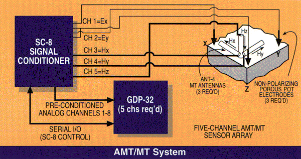
Each equipment box in the diagram above is linked to the corresponding specification file.
Applications:
- Mining Exploration
- Petroleum Exploration
- Geothermal Exploration
Papers and Case Histories
Introduction to NSAMT
[Abstract]
[Paper PDF:1152k]
NSAMT Natural Source Audio Frequency Magnetotelluric Imaging
[Abstract]
[Paper PDF:1269k]
NSAMT is a passive electromagnetic imaging technique using the earth's magnetotelluric field to map geologic contacts and structure typically to depths of 500 meters or more. With the lower MT frequencies, imaging can be extended deeper. The ability of identify geologic features varies with depth and depends upon target size, resistivity contrasts and contact geometry.
The Zonge AMT system can be configured to investigate a number of different targets by selecting an appropriate array configuration and frequency bandwidth. Besides selecting suitable dipoles for measuring the electric field, the AMT array is easily configured to collect CSAMT-type scalar, vector or tensor field data. All of these data are easily processed with Zonge Engineering DATPRO©; software with results imaged by SCS2D inversion software. In this paper, examples of 2-D imaged scalar and tensor NSAMT data demonstrate different applications.
The Inversion of Magnetotelluric Data and the Elimination of Topographic Effects Through Modeling
[Abstract]
[Paper PDF:1215k]
Rough topography may cause severe distortion in imaging based on AMT data acquired with the electric field oriented perpendicular to geologic strike, ie. TM-mode data. Topographic peaks create high-angle conductive distortion while topographic valleys create high-angle resistive features in TM-mode AMT data. Topographic distortions will be carried through to produce high-angle conductive or resistive artifacts in inversion models unless the imaging procedure accounts for the distortion. SCSINV 1-D resistivity-depth images are affected by 2-D topography, while SCS2D 2-D inversions with models including a topographic profile do not.
TE-mode magnetotelluric data, with the electric field oriented parallel to geologic strike, is distorted less by 2-D topography than is TM-mode data. However collecting TE-mode is generally impractical when collecting closely spaced data along survey lines oriented perpendicular to geologic strike. Continuous AMT production is optimized when electric-field dipoles are positioned along survey lines to collect TM-mode data. In contrast, aligning electric field dipoles perpendicular to survey lines to collect TE-mode data is time consuming (and expensive). As a result, most closely sampled AMT data are collected in the scalar TM-mode. Consequently, this paper focuses mostly on the effects of topography upon the interpretation of TM-mode AMT data, although some TE-mode results are included.

