
Method
Introduction
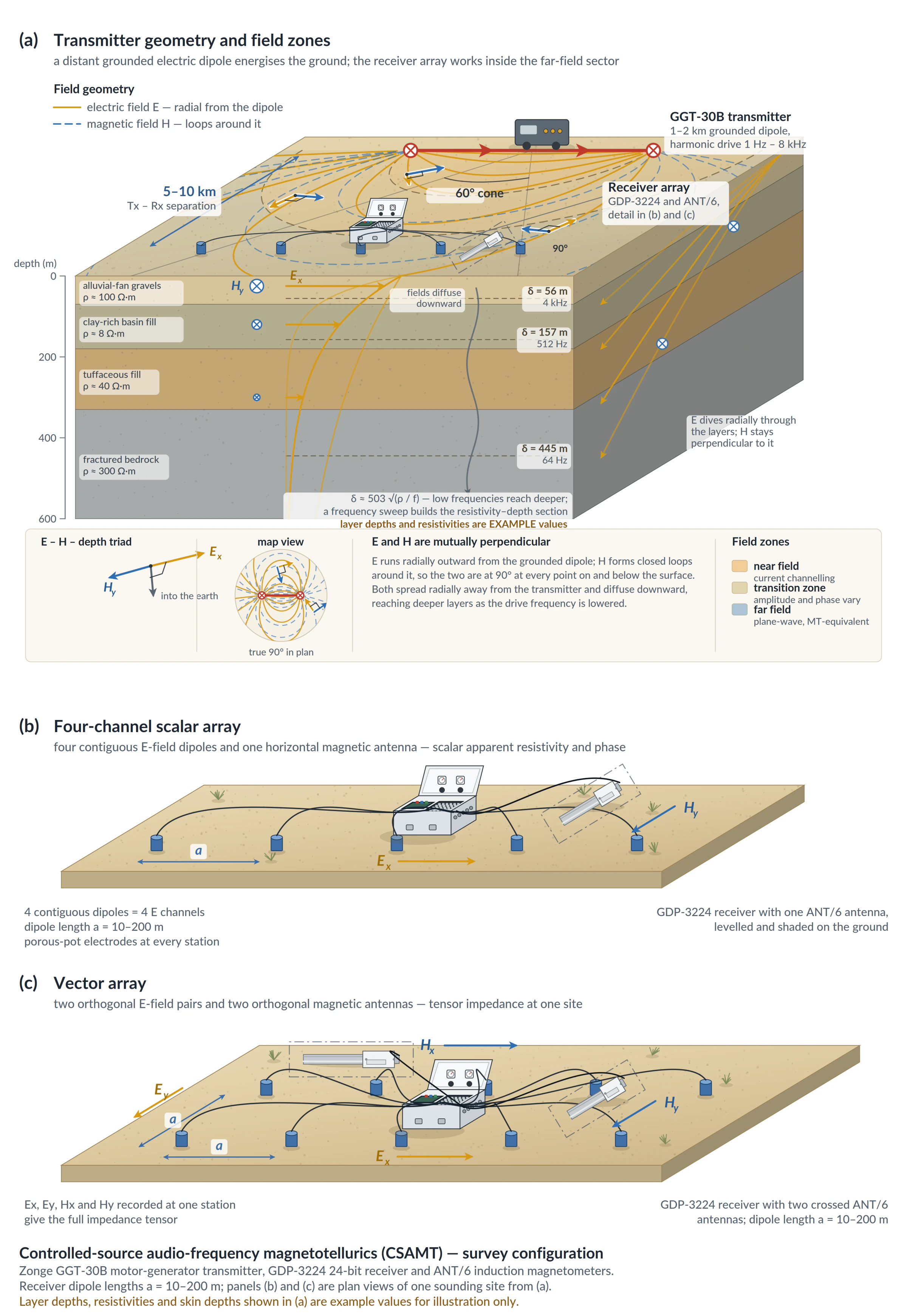
Controlled-source audio magnetotellurics (CSAMT) measures the resistivity of the Earth by transmitting a controlled signal from a distant grounded dipole and recording orthogonal electric and magnetic field components across a range of frequencies. The resulting resistivity response is used to map lithologic contrasts, structures, alteration zones, and hydrogeologic boundaries.
Applications
CSAMT is widely used to image resistivity structure where geologic targets are controlled by lithology, fluid content, alteration, or faulting.
- Depth to bedrock, basin geometry, and major geologic contacts
- Silicified structures, breccia zones, and fluid pathways
- Faults and shear zones with resistive or conductive alteration halos
- Water-table trends, aquitards, and groundwater framework mapping
- Mineral, geothermal.
Related applications: mining exploration, geothermal exploration, and groundwater exploration.
Survey Design
| Parameter | Description |
|---|---|
| Depth | Depth depends on transmitted frequency and subsurface resistivity, with many surveys targeting the upper hundreds of meters. |
| Dipole Length | Receiver dipoles are commonly 10-200 m, selected to balance signal strength, resolution, and logistical efficiency. |
| Scale | Surveys are typically acquired as profiles or localized grids with multiple dipoles recorded at each setup. |
| Production | Profiles are commonly completed over days, with daily production influenced by terrain, dipole layout, and signal quality. |
Instrumentation
- Receiver: GDP-3224 Multi-Function Geophysical Receiver (24-bit, multi-channel)
- Magnetic Antenna: ANT-6
- Transmitters: GGT-30B and GGT-10B
- Generators: ZMG-30DLE or ZMG-9A
Deliverables
- Pseudosections of observed Cagniard resistivity and impedance phase
- Two-dimensional inversion sections showing resistivity versus depth
- Plan maps of inversion results at selected elevations
- 3D resistivity models with horizontal depth slices
Case Studies and Resources
Selected third-party project references are listed below. Project interpretations and results are reported by the cited publishers.
- 20 line-km CSAMT program at Table Mountain, Nevada — Toogood Gold Corp., Jul 2026
- CSAMT results and drill targeting at Stockade Mountain, Oregon — Austin Gold Corp., Jun 2026
- 11.2 line-km CSAMT survey at Bellehelen, Nevada — Excalibur Metals Corp., Feb 2026
- Property-wide CSAMT and the Silver Sage discovery targets, Alaska — Alaska Silver Corp., Nov 2025
- CSAMT data from the Gooseberry silver project, Nevada — American Pacific Mining Corp., Feb 2023
- Contact Zonge for CSAMT project examples, deliverable samples, and references relevant to your survey objectives.